Posts made in November 2019

Tillery Pines Lot #5 SOLD

Details

County: Halifax
State: NC
Acreage: 1.45
Cash Price: $15,999
15% Down: $2,400
Monthly Payment: $120
Association Fees: None

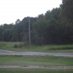
Electricity: Underground power on all lots
Water: By Well or city hookup
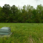
Waste: By Septic, perc test on file
Zoning: Res/Ag
Covenants: None
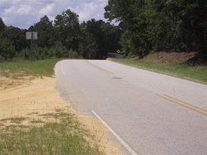
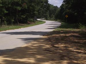
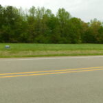
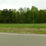
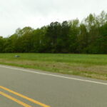
Access: County Road Frontage
Time-Limit To Build: None
Liens & Judgments: None

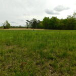
Property Description: Professionally surveyed residental lots.

All lots have road frontage. All lots are buildable. All lots have underground power. All lots have had perc test and is on file. City water available

Come enjoy the serenity of Tillery and build that home you have always wanted.

These ranchettes are located at the intersection of Gravel Pit Road and US HWY 561 in Tillery, NC.
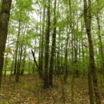
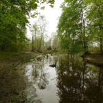
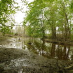
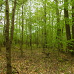
Nashville and Rocky Mount can be reached within 40 minutes and Wilson in less than an hour. Nash and Wilson County are thriving communities with convenience to the metropolitan areas of Raleigh, Durham and Chapel Hill. If you have been looking for an affordable home site, then this is the property for you. Your neighboring properties are primarily all wooded tracts of timber and farmland. Roanoke Rapids Lake, is known for top-notch fishing and duck hunting. The lake is located north of Tillery, Roanoke Rapids, NC, and can be reached within 35 minutes. Located in northern Halifax County, along the former Roanoke River channel that forms North Carolina’s common boundary with Virginia, Roanoke Rapids Lake is a moderate-sized body of water of more than 4,600 acres. However, it’s large enough to support a sizeable winter population of diving ducks. Puddle ducks have always migrated along the Roanoke River’s floodplain, using the hardwood bottoms for feeding, resting and wintering habitat. Downstream of Roanoke Rapids Lake these migratory puddle ducks, especially mallards and wood ducks, still hold sway as the predominant species in the river bottoms.

Boonville Ranch Lot #3, 7.21 acres SOLD

This slideshow requires JavaScript.

Details


State: New York
County: Oneida
Acreage: 7.21
Sale Price: $19,827.50
Down Payment: 15%, $2,975 (Down payment can be split up into 6 equal monthly payments of $495, after which normal monthly payments start.)
Monthly: $163
Property Taxes: $520
Association Fees: None
Electricity: Power down the street
Telephone: Good cell service
Water: By Well, not installed
Waste: By Septic, not installed
Zoning: Res/Ag
Covenants: None
Access: County Road Paved Frontage
Time-Limit To Build: None
Liens & Judgments: None

Property Description:

Professionally surveyed Ag/Residental ranch size lot.
All lots have road paved frontage. All lots are buildable. All lots have power down the street.

Come enjoy this late 1700's Village of Boonville, New York, 13309. These mini ranch, surveyed, semi-wooded parcels are the ideal spot to build a vacation cabin or your new home.

Boonville is located at GPS coordinates 43°28′59″N 75°19′55″W (43.483201, -75.331945). According to the United States Census Bureau, the village has a total area of 1.8 square miles. None of the area is covered with water. Boonville is at the convergence of New York State Route 12, NYS Route 12D, NYS Route 46, and NYS Route 294. Check the gps coordinates listed on the parcel ads to be sure where you are. Boonville is @ 5hrs from Grand Central Station, less than 5 hrs from Montreal Canada, and @2 hrs from Albany.

The New York Woodsmen's Field Days is held annually, rain or shine, on the third full weekend in August. This event includes forestry exhibits, fireworks, greased pole climb, lumberjack/jill contests, woods craftsmen and it's all kicked off with the Woodsmen's Parade. Contestants travel from as far away as Canada, Australia, and New Zealand to compete in the Lumberjack festivals. The Boonville Snow Festival is held annually in late January and consists of vintage snowmobile races, ice sculptures, parade, and fireworks. Local area businesses join in on the Festival of lights sponsored by the Boonville Chamber of Commerce.

The Boonville Historic District is a must see. Erwin Library and Pratt House, Black River Canal Warehouse, Five Lock Combine and Locks 37 and 38, Black River Canal, and United States Post Office are all listed on the National Register of Historic Places.

Summertown Country Estates Lot #6 SOLD

Summertown Country Estates lot six

Details

County: Emanuel
State: GA
Acreage: 2.5
Cash Price: $14,950
10% Down: $1,495
Monthly: $130
Interest Rate: 9.99%

Property Description: Professionally surveyed 2.5 acre estate size lot.

All lots have road frontage. All lots are buildable. Come enjoy the serenity of Summertown and build that home you have always wanted. Summertown is in northern Emanuel County Georgia. State Route 56 passes through the east side of the city limits, leading north 5 miles (8 km) to Midville and south 11 miles (18 km) to Swainsboro, the county seat. Summertown Church Road West is located in Summertown, only 10 miles North of Swainsboro. Road frontage is on Summertown Church Road. The property contains 2015 Loblolly Pines plantations and can be easily converted into agricultural land. Summertown, Georgia, gets @46 inches of rain per year. The US average is 39. Snowfall is 0 inches. The average US city gets 26 inches of snow per year. The number of days with any measurable precipitation is 68. On average, there are 222 sunny days per year in Summertown, Georgia. The July high is around 93 degrees. The January low is 36.

Deed Restrictions: Exhibit "A"

DEED RESTRICTIONS FOR SUMMERTOWN COUNTRY ESTATES, EMANUEL COUNTY, GA The properties (lots 1-17) to be covered by these Deed Restrictions are shown on the plat of survey for Robert Pratt, prepared by G. William Donaldson, Georgia Registered Land Surveyor No. 1970, dated July 25, 2017, recorded in Plat Book 23, Page 74, Emanuel County Superior Court records, which said plat is incorporated herein and made a part of this legal description. The hereinabove described property is a portion of that certain property described in Deed Book 354, Page 520 and Deed Book 409, Page 506, said Clerk’s Office.

  1. No commercial operations (for example: automotive repair, welding shops, used car sales, stores, etc.).
  2. 'No landfills, quarries or junk yards.
  3. No mobile home or RV parks.
  4. Forestry and agricultural operations are allowed with the exception of, commercial chicken houses hog houses and feed lots.
  5. Single family homes only: double-wide mobile homes, modular homes, and site-built homes with a minimum of 900 square feet of heated space are allowed.
  6. No more than one single family residence allowed for every 2.0 acres of ownership.
  7. Separate garages and outbuildings will be allowed to support each single-family residence.
  8. The above restrictions are intended to be the minimums set for this property and are not intended to supersede any of the ordinances and restrictions of the City of Summertown and Emanuel County which may call for more restrictive uses now or in the future.

Summertown Country Estates Lot #5 SOLD

Summertown Country Estates lot five

Details

County: Emanuel
State: GA
Acreage: 2.5
Cash Price: $14,950
10% Down: $1,495
Monthly: $130
Interest Rate: 9.99%

Property Description: Professionally surveyed 2.5 acre estate size lot.

All lots have road frontage. All lots are buildable. Come enjoy the serenity of Summertown and build that home you have always wanted. Summertown is in northern Emanuel County Georgia. State Route 56 passes through the east side of the city limits, leading north 5 miles (8 km) to Midville and south 11 miles (18 km) to Swainsboro, the county seat. Summertown Church Road West is located in Summertown, only 10 miles North of Swainsboro. Road frontage is on Summertown Church Road. The property contains 2015 Loblolly Pines plantations and can be easily converted into agricultural land. Summertown, Georgia, gets @46 inches of rain per year. The US average is 39. Snowfall is 0 inches. The average US city gets 26 inches of snow per year. The number of days with any measurable precipitation is 68. On average, there are 222 sunny days per year in Summertown, Georgia. The July high is around 93 degrees. The January low is 36.

Deed Restrictions: Exhibit "A"

DEED RESTRICTIONS FOR SUMMERTOWN COUNTRY ESTATES, EMANUEL COUNTY, GA The properties (lots 1-17) to be covered by these Deed Restrictions are shown on the plat of survey for Robert Pratt, prepared by G. William Donaldson, Georgia Registered Land Surveyor No. 1970, dated July 25, 2017, recorded in Plat Book 23, Page 74, Emanuel County Superior Court records, which said plat is incorporated herein and made a part of this legal description. The hereinabove described property is a portion of that certain property described in Deed Book 354, Page 520 and Deed Book 409, Page 506, said Clerk’s Office.

  1. No commercial operations (for example: automotive repair, welding shops, used car sales, stores, etc.).
  2. No landfills, quarries or junk yards.
  3. No mobile home or RV parks.
  4. Forestry and agricultural operations are allowed with the exception of, commercial chicken houses hog houses and feed lots.
  5. Single family homes only: double-wide mobile homes, modular homes, and site-built homes with a minimum of 900 square feet of heated space are allowed.
  6. No more than one single family residence allowed for every 2.0 acres of ownership.
  7. Separate garages and outbuildings will be allowed to support each single-family residence.
  8. The above restrictions are intended to be the minimums set for this property and are not intended to supersede any of the ordinances and restrictions of the City of Summertown and Emanuel County which may call for more restrictive uses now or in the future.